• There were many reasons for the change of the site software, the biggest was security. The age of the old software also meant no server updates for certain programs. There are many benefits to the new software, one of the biggest is the mobile functionality. Ill fix up some stuff in the coming days, we'll also try to get some of the old addons back or the data imported back into the site like the garage. To create a thread or to reply with a post is basically the same as it was in the prior software. The default style of the site is light colored, but i temporarily added a darker colored style, to change you can find a link at the bottom of the site.

Today I tried navigation via BRP Go (2024+)...

Google says:
Well, Google is again, not accurate (no big surprise there, given it's increasing dependence on AI to find answers).

I did however discover where Itineraries are stored!!!!

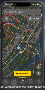
When you open the app to the main navigation screen you will see a squiggle in the upper left of the screen below the search screen. Click on that and it will show you Itineraries and Completed. Names Itineraries can be found there, brought up to start the ride, edited and again saved. Of course none of this is intuitive or explained by BRP.

BRP GO screen1.png

Now I only have to get the bike to recognize the phone.

Baby steps.

jdg
 
I can confirm this, I have planned and ridden several itineraries created in BRP Go, they are all there, accessing the map and tapping the icon on the top left (like the picture above). Also from there you can rename, delete, duplicate, or share any previously created itinerary. There's an interesting feature from which you can share the itinerary to a group... Groups are created on the entry screen under social.

But I've seen no possibility to create shaping points, only via points... This means while navigating you get the info for the next via point.

So let's say an itinerary that includes only 3 points: start, middle via point, end... As soon as you start navigating it displays the time and distance to the middle via point. Only after getting there, it will display the distance and ETA to the end... With a middle shaping point instead of a via point I would have the ETA and distance to the end... So to create shaping points, there’s really no other way than creating via points, in order to force the itinerary to pass through them - which isn’t exactly the purpose of a via point, since it’s meant to mark a stop or a waypoint in the route.

But I can honestly see a lot of potential in this application. I know that the ability to map other friends’ Spyders on the map is planned, so you can locate friends and organize group rides. I believe that for this, the GPS module is required - which, as far as I know, was introduced starting in 2025. I sincerely hope that BRP’s engineers invest in this solution (the hardware seems more than capable), since, unfortunately and sadly, I doubt that Android Auto will ever be supported.
 
I finally downloaded the app (Android - Pixel 7 Pro if it matters), created the account and added my Spyder by VIN (that actually worked). My software is current and BRP Go has been selected as the navigation software. So far so good. However, the bike will not see the phone when it's plugged in, and yes, I even have a stupid and functionally useless 6" cable for testing. For the life of me, I can't figure out how to get the bike to see the phone. I added a Bluetooth connection just in case, and it appears that the phone is sync'd to the bike.
I'll ask the obvious question, and hope I'm not insulting your intelligence: Is that 6" cable a USB data cable, or is it simply a charging cable? Test it by connecting your phone to a computer with it.
 
I believe that for this, the GPS module is required - which, as far as I know, was introduced starting in 2025. I sincerely hope that BRP’s engineers invest in this solution (the hardware seems more than capable), since, unfortunately and sadly, I doubt that Android Auto will ever be supported.

There was a previous discussion about the BRP plug-in GPS module, but the information on the BRP site was pretty specific that it was for SkiDoo models, not CAN-AM 3-wheelers.

All of the BRP/CAN-AM information I've found about the GPS capabilities of CAN-AM 3-wheelers are either Apple Carplay or more recently BRP GO running on your phone connecting to the BRP Connect software on your bike.
 
There was a previous discussion about the BRP plug-in GPS module, but the information on the BRP site was pretty specific that it was for SkiDoo models, not CAN-AM 3-wheelers.

All of the BRP/CAN-AM information I've found about the GPS capabilities of CAN-AM 3-wheelers are either Apple Carplay or more recently BRP GO running on your phone connecting to the BRP Connect software on your bike.

Just checked it's been listed since 2024.

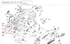
2026-07-20 185455.jpg
 
Just checked it's been listed since 2024.
Interesting, as it does say that fits a very long list of Canyon, F3, and RT models starting in 2024.

But I haven't been able to find any information about how to use it on CAN-AM 3-wheelers.
There is a CAN-AM site that talks about using it in the Off Road Vehicles (ORV):


The built-in GPS is only available on ORV models equipped with the 10.25” display.
 
Interesting, as it does say that fits a very long list of Canyon, F3, and RT models starting in 2024.

But I haven't been able to find any information about how to use it on CAN-AM 3-wheelers.
There is a CAN-AM site that talks about using it in the Off Road Vehicles (ORV):


From what I've read, it's needed for the "social" features, like group rides/sharing your position with others.

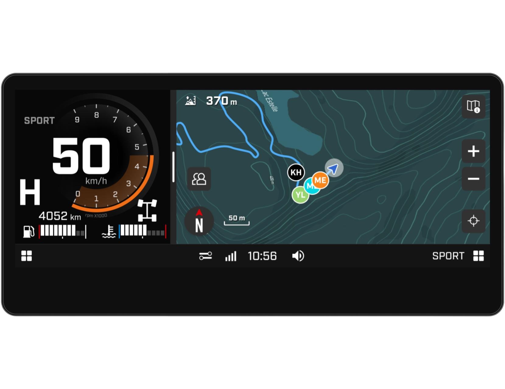
But yes, the off-road vehicles support navigation through a topographic map that is loaded (through wifi) to the unit without any mobile phone connection.

So maybe the on-road navigation (routing) inside the unit (or through a wifi connection) could be planned for a near future...
 
A quick check with Google says that the BRP GO! app allows you to invite other people to a ride you plan, which might require they are also on CAN-AMs using BRP-GO/BRP Connect.
 
A quick check with Google says that the BRP GO! app allows you to invite other people to a ride you plan, which might require they are also on CAN-AMs using BRP-GO/BRP Connect.

I would say, you can't go away without any available network to send and receive each other locations, so it should be either cable or wifi to access the network of the mobile phone.

But then there's this:

  • Embedded topographic maps and GPS function included
  • Available in the USA, Canada, and Europe
  • Enables live location sharing offline for group members and other BRP vehicles around
  • Note: Does not show snowmobile trails in Ontario (OFSC), only topographic maps
  • Works without a phone connection or cellular network
  • Range of 1+ mile (1.6+ km) depending on the terrain
  • Standard on 2026 or newer models with the 10.25″ Touch Display, can be installed on 2025 or older models with the same display
  • Module must be installed by the dealership

Looks similar to the one listed for the Spyder but part number is different, so offline location sharing and group ride might work differently, being the first very limited in range (1 mile).
 
OK, so I may just be stupid at this point, but I'll ask anyway...

I finally downloaded the app (Android - Pixel 7 Pro if it matters), created the account and added my Spyder by VIN (that actually worked). My software is current and BRP Go has been selected as the navigation software. So far so good. However, the bike will not see the phone when it's plugged in, and yes, I even have a stupid and functionally useless 6" cable for testing. For the life of me, I can't figure out how to get the bike to see the phone. I added a Bluetooth connection just in case, and it appears that the phone is sync'd to the bike.

Additionally, unless I'm missing something else (and I hope I am), I don't see any way to save a trip for later use. It appears to me that you plot your trip, plug in the phone and take off. If you close the app, the trip goes away!

I hope I'm missing something, or a lot of somethings. Fortunately, my Garmin Zumo 665 still works just like it should.

jdg
I've got a 665 and Garmin says its no longer supported. I still see the maps, but there's no longer any POI or even fuel stops. How to get that working again? Still on my '14 RT and I drove a new one in Deadwood, but I don't see the attraction. And reading about these horrors with nav and display probs - geez!
 
I've got a 665 and Garmin says its no longer supported. I still see the maps, but there's no longer any POI or even fuel stops. How to get that working again? Still on my '14 RT and I drove a new one in Deadwood, but I don't see the attraction. And reading about these horrors with nav and display probs - geez!
Google says the Garmin Zumo 665 was released in January 2010, so I'm not too surprised that Garmin is no longer providing updates.

The way to get it working again is to sell it on eBay and use the money to help pay for the newest Garmin motorcycle GPS, the Garmin XT3.
 
The Ski-Doo GPS module does not use your cell phone to track the other riders in your group.


On that BRP page it says:

Stay connected on every ride thanks to the GPS module with Group Ride. It enables you to share your location at a 1+ mile (1.6 km) radius, even without a phone connection or cellular network nearby.


I also found this:

How it Works
    • Offline Connectivity: The system uses short-range vehicle-to-vehicle tech (with a range of over 1.6+ km / 1+ mile depending on the terrain) rather than cellular data.
    • Create & Join: One person creates a group, which generates a short join code. Group members navigate to the group/buddy icon on their display, punch in the code, and their friends appear as colored arrows on the map.
    • Other BRP Riders: Even if you aren’t in their group, any other BRP riders with the Group Ride module in your immediate vicinity will show up as black icons.

Notice the "Create & Join" part? You have to invite someone to join your group, and they have to accept the invitation.
But it still tracks other BRP vehicles that have the GPS module, even if they aren't part of your group.

Google thinks it uses a radio signal, which is why the range is limited to about 1 mile.

I also saw a note that said it has to be installed by a dealer as it also requires a BUDS software update.
 
I've got a 665 and Garmin says its no longer supported. I still see the maps, but there's no longer any POI or even fuel stops. How to get that working again? Still on my '14 RT and I drove a new one in Deadwood, but I don't see the attraction. And reading about these horrors with nav and display probs - geez!
Yeah, Garmin hasn't really supported the 665 for a number of years. I side load the new maps since they will not download from Garmin any more. My 660s still get the current maps, and I also have a 590, so getting the current maps is not an issue. I run a program to unlock the map once I built it in MapInstall. Seems to have all the POI stuff, including gas stations. Had to do that with my Goldwing as well since Honda and Garmin didn't update the maps after something like 2018 for the older GL1800s.

I stay with my 665 as it supports both XM radio (and weather) and mp3 playback. It looks like the new XT3 again supports internal mp3 playback, but still no XM radio support.

I'll ask the obvious question, and hope I'm not insulting your intelligence: Is that 6" cable a USB data cable, or is it simply a charging cable? Test it by connecting your phone to a computer with it.
Yep, it's a data cable. I did double check just to make sure. Thanks,

jdg
 
Little update.

+2 hour ride today, tried a new "fast" braided cable from Amazon, just lost connection momentarily once.

Locked the phone charging to 80% and it was exactly at 80% at the end of the ride. A bit hot, but surely the USB port can deliver much more than 500mA? This time I was able to navigate with BRP Go for more than 2 hours and keep the charge, so the cable definitely makes a difference.

Phone was connected to the Spyder bluetooth. As said before, no voice guidance (which is difficult to understand why) but spotify worked perfectly the whole time without any hiccups.

I really liked the automatic routing after a couple of detours from the original planning, it found a correct alternative path right away.

Annoying things:

Seems it's only possible to record a drive or navigate, not both... kind of lame.

Creating the route through via points (or waypoints) in the App is easy, but then there's no possibility to change the name.
So you end up with a bunch of "Custom pin location" and while navigating that's only what you'll see on the dashboard, pretty useless.

Planning to wire in my Garmin Zumo next week, but I can see definitely BRP Go as a quick option, I surely hope BRP technicians are working on it and listening the customer's feedback.
 
It's a USB 2.0 port, which by definition is 5V and 500mA.
In reality, often the real world devices within embedded systems on a chip fail to even provide that rated power.

I've found by experience that most of these devices fail to meet their declared power rating and even their data rates fall well short of the expected specification.

The only thing I can think of, and I'm not sure if the USB port recognizes them, is to provide a hub powered from the accessory outlet on the bike. I can only assume it might, as there are accessories out there that supply multiple USB ports, but I suppose they may only be one port for data and the rest just for power. I have a small hub that I'm going to try when the temperature in my garage drops below 100°F again.

I'll plug the power for the hub into a 110V outlet via a wall wart, plug the dash USB into the host side of the hub, and then test to see if each of the output ports on the hub will connect to CarPlay before I bother to wire it into the bike's 12v accessory power.

If you have a USB hub available that test will prove whether it works on not. You can bring power into the glove box where you can fit a small multi port hub. A powered hub should give you more than enough power, you just have to find out whether the USB port on the Spyder supports hubs or not.

--------------

On second thoughts it might not work. The phone might negotiate the power with the host, the Spyder, not the hub. You'll probably have to try it and see.

--------------

If this doesn't work try the following on Amazon, it's like $12. It takes its power from a USB C port. You'll need a USB A male to USB C male data adapter to attach it to the Spyder USB A port.

USB 2.0 Type C Signal Separator, Aluminum Alloy USB C Power Splitter Module​
USB 3.0/3.1 Male to USB-C Male Adapter (2 Pack), OTG 3.0/3.1 USB A to Type-C Adapter, Fast Data Transfer up to Gen2 10Gbps, USB C Connector Connection or Data Cable Extension​
Waterproof DC 12V/24V to 5V 3A Buck Converter, USB-C Output | Stable 5V/3A Output, Waterproof Sealed Enclosure, Built-in Multi-Protection​
Green Jiss® USB C Extension Cable 5ft, 20Gbps/4K@60Hz Video, Heavy Duty USB3.2 Gen2 Extender Male to Female Full Function Ultra-High Speed Transfer USB Type C Extender 240W Fast Charging Cable​

In order to get ignition switched 12V power from the Spyder you will need the following from SlingMods:

Plug N' Play 12V Aftermarket Accessory Quick-Connect Power Harness for the Can-Am Spyder RT (2020+)​

So what does all this stuff mean:

1. The SlingMods harness will give you 12V power.​
2. The Buck Converter will convert 12V power to a USB 5V supply. Its bare end wires will connect with the push down connectors on the SlingMods harness.​
3. The USB C cable will take power from the USB output of the Buck 12V to 5V Converter up to the glove box over a quality USB C cable.​
4. The signal separator will take the Spyder USB A cable, via the USB A to USB C convertor to the host side of the signal separator.​
5. The USB C cable you ran from the power converter to the glove box will plug into the USB power input on the other side of the signal separator.​
6. From the USB C output of the signal separator you run a quality USB C data cable to the phone, USB C male to USB C male assuming your phone is USB C. Id didn't specify this as I have no idea how long you want it. Use a high quality USB C data cable.​

What you are doing here with the signal separator is that the data at the low wattage comes from the Spyder to the separator. The USB power is then stripped and the data is forwarded to the phone at the power rating supplied by the signal separator to the phone. So, the phone negotiates power level from the power separator, not the Spyder. The other parts are just a way to get 12V power from the Spyder turned into 5V USB C power to power up the signal separator. I suggest using electrical tape down at the SlingMods harness end of things. The power convertor is already waterproof.

I hope one or the other systems works for you.

 
Last edited:
I added a docking station to my 2024 Spyder RT S2S from Spyder Extras.
It is wired into the accessory power port on the right front side of the Spyder.
It worked well for use with a Garmin Zumo XT GPS before CAN-AM got Apple CarPlay working.

Now I ride with a QuadLock mount and QuadLock iPhone case for my iPhone SE 2nd Gen, with a Belkin braided USB C to USB A cable to connect my iPhone to the USB A port in the "glove box" in front of the handle bars.

I haven't had a problem with the Spyder's USB port keeping my iPhone charged.
Although I do have to admit that I always plug my iPhone into a wall charger at night, so it's fully charged when I leave the house.


What you're thinking about doing seems like an expensive and complicated project with little proof that it will add any real value, but that's just my opinion.

And now I want to go for a ride, but it's 5:20 in the morning. :(
 
Locked the phone charging to 80% and it was exactly at 80% at the end of the ride. A bit hot, but surely the USB port can deliver much more than 500mA?
I've found by experience that most of these devices fail to meet their declared power rating and even their data rates fall well short of the expected specification.

I've quoted two of your posts because it occurred to me that they contradict each other.

You say you configured your phone to stop charging at 80%, something that Google confirmed is an option, but of which I wasn't aware. And after your ride the phone was at exactly 80%. So the USB port provided enough power to keep your phone charged to the 80% level you set during your ride that lasted more than 2 hours.

But you say that you believe most USB devices fail to deliver the amount of power that the USB design specification claims.

It seems to me that for those two hours the USB port delivered enough power for what you needed, even if it was a lower amount than the spec calls for.

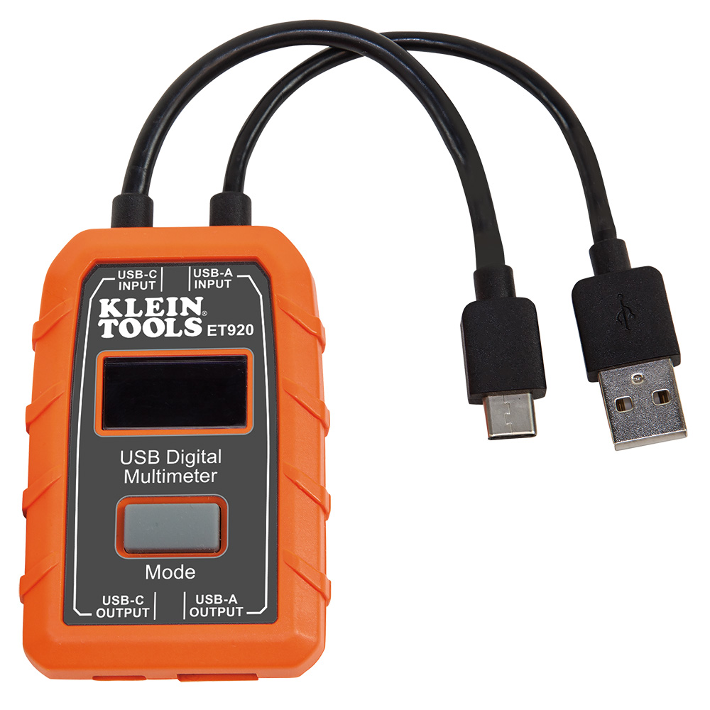
As for testing the USB port, both Home Depot and Lowe's sell a Klein Tools USB Digital Meter for US $39.97.
It has USB A and C cables attached on one end of the device, and USB A and C ports on the opposite end.
You plug the attached cable into the port you want to test, and you plug your USB device's cable into the port on the device and then test.

 
Back
Top