-
There were many reasons for the change of the site software, the biggest was security. The age of the old software also meant no server updates for certain programs. There are many benefits to the new software, one of the biggest is the mobile functionality. Ill fix up some stuff in the coming days, we'll also try to get some of the old addons back or the data imported back into the site like the garage. To create a thread or to reply with a post is basically the same as it was in the prior software. The default style of the site is light colored, but i temporarily added a darker colored style, to change you can find a link at the bottom of the site.
You are using an out of date browser. It may not display this or other websites correctly.
You should upgrade or use an alternative browser.
You should upgrade or use an alternative browser.
the flooding down south.
- Thread starter cuznjohn
- Start date
SPECTACUALR SPIDERMAN
Active member
is charlene his spyder?
Bob Denman
New member
That's his Wife/Sister/1st-2nd-3rd and 5th cousin/Great-Aunt/ and Grandmother! :yikes:
IdahoMtnSpyder
Well-known member
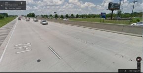
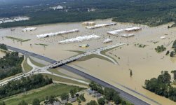
I was talking to the folks who bought our house outside Hammond, LA when we left there 10 years ago. She said one of the big reasons Denham Springs, just east of Baton Rouge, flooded so badly was a median barrier constructed on I-12 with no way for water to pass through it. Some real "smart" highway design choices seriously aggravated the disaster.


Orange Spyder Man
New member
sorry... but your explanation is incorrect... the reason for this massive flooding was because rain totals were in excess of 37" in less than 12 hours in areas that grounds had been soaked with unseasonable large amounts of rain... thus the rivers that drain these areas simply could not handle the massive amounts of water..
40,000 homes flooded in just the Denham Springs area... this area is a flood plain.. if you unfamiliar with this term look it up for clarification..
in the Hammond, Gonzales, Prairieville area were also flooded .. from back waters of the Pearl River.. this area has never before recorded this much rain in 3 day period.. lots of lives will be disrupted for many years to come... that picture you posted does not indicate the real picture... one has to look at the whole picture... look 3 miles in either direction to see the actual problem.. its the Pearl River.. it overflowed its banks because of extreme amounts of rain north & south of this particular area... levees build by man contained other areas from flooding... unfortunately growth out ran the levee protection system which is shown in your picture..
osm
QUOTE=IdahoMtnSpyder;1171213]I was talking to the folks who bought our house outside Hammond, LA when we left there 10 years ago. She said one of the big reasons Denham Springs, just east of Baton Rouge, flooded so badly was a median barrier constructed on I-12 with no way for water to pass through it. Some real "smart" highway design choices seriously aggravated the disaster.
View attachment 136172
View attachment 136171[/QUOTE]
Last edited:
Bob Denman
New member
On FoxNews this morning: they mentioned that 30" of rain had fallen... is that number accurate? :shocked:
vided
New member
On FoxNews this morning: they mentioned that 30" of rain had fallen... is that number accurate? :shocked:
it's fair and balanced
IdahoMtnSpyder
Well-known member
[/QUOTE]sorry... but your explanation is incorrect... the reason for this massive flooding was because rain totals were in excess of 37" in less than 12 hours in areas that grounds had been soaked with unseasonable large amounts of rain... thus the rivers that drain these areas simply could not handle the massive amounts of water..
40,000 homes flooded in just the Denham Springs area... this area is a flood plain.. if you unfamiliar with this term look it up for clarification..
in the Hammond, Gonzales, Prairieville area were also flooded .. from back waters of the Pearl River.. this area has never before recorded this much rain in 3 day period.. lots of lives will be disrupted for many years to come... that picture you posted does not indicate the real picture... one has to look at the whole picture... look 3 miles in either direction to see the actual problem.. its the Pearl River.. it overflowed its banks because of extreme amounts of rain north & south of this particular area... levees build by man contained other areas from flooding... unfortunately growth out ran the levee protection system which is shown in your picture..
osm
QUOTE=IdahoMtnSpyder;1171213]I was talking to the folks who bought our house outside Hammond, LA when we left there 10 years ago. She said one of the big reasons Denham Springs, just east of Baton Rouge, flooded so badly was a median barrier constructed on I-12 with no way for water to pass through it. Some real "smart" highway design choices seriously aggravated the disaster.
View attachment 136172
View attachment 136171
You're correct, but the barrier aggravated the flooding.
Sent from my SM-T350 using Tapatalk
Orange Spyder Man
New member
Bob...YES ... quite accurate ... in Walker, La (which is just north of Baton Rouge... it was reported 37" of rain fell in less than 12 hours...
never before in history has this area sustained such flooding... these people needs help & prayers...
osm
never before in history has this area sustained such flooding... these people needs help & prayers...
osm
On FoxNews this morning: they mentioned that 30" of rain had fallen... is that number accurate? :shocked:
Orange Spyder Man
New member
well, both sides of the interstate north & south received flooding .. its quite apparent in the pictures you posted... but in actuality if you view the entire area between Baton Rouge & Hammond... the flooding is extensive.. from Hammond to Baton Rouge, north to Walker & south to Gonzales flooding like this has never been recorded before in these areas...
osm
You're correct, but the barrier aggravated the flooding.
Sent from my SM-T350 using Tapatalk[/QUOTE]
osm
You're correct, but the barrier aggravated the flooding.
Sent from my SM-T350 using Tapatalk[/QUOTE]
Bob Denman
New member
I guess that nobody can plan for that much rain... The best that you can hope for, is to not be there when it happens. nojoke
IdahoMtnSpyder
Well-known member
Minor correction, Walker is east of BR and Denham Springs. What's somewhat interesting, I think, is that even though the rain was historically intensive, in the grand view of the entire state and Gulf Coast it was actually quite limited in area and not any more wide spread than previous rain induced floods. But it was deeper. When I talked to the folks, Fred and Sheron, who bought the house we used to own west of Hammond/Ponchatoula, the water had not approached the house hardly any closer than back in 1995 when more than 20" of rain fell on New Orleans in 24 hours. Back in 1997, I think, the Bayou Choctaw oil storage site outside of Plaquemine was flooded. That was largely from rain that fell around the Baton Rouge area and west and flowed south. In our conversation Sheron said that Bayou Choctaw had not flooded at all from this latest rain.well, both sides of the interstate north & south received flooding .. its quite apparent in the pictures you posted... but in actuality if you view the entire area between Baton Rouge & Hammond... the flooding is extensive.. from Hammond to Baton Rouge, north to Walker & south to Gonzales flooding like this has never been recorded before in these areas...
osm
This was a weird rain and flood. Extremely heavy but very limited in area. The previous rains such as the 1995 one were much larger in area than this last one and flooded a much larger land area but not as deeply.
CapeSpyder
New member
Too.many in my family have been affected by the rain. 34" under my brothers house. Thank god he was smart som many years ago and built 8' up.
CapeSpyder
Sent From my Note 5
CapeSpyder
Sent From my Note 5
Orange Spyder Man
New member
yeah... the pres. is working on his game... but ... if you missed it on TV ... Trump did make it... ... 
Prayer go out to all those affected. Nice to see Mr. President continue to play golf.
Orange Spyder Man
New member
oops .. you are correct about Walker... I did not go back & check my post before posting... sorry.. it appears the Amite & Pearl river and their drain basins could not handle such an enormous amount of rain fall... which contributed to lots of the flooding... I have a friend that lives in Prairieville we talked yesterday morning and he still had 22" of water inside of his house... be had 2 motorcycles in his garage and both were submerged in water...so many homes are completely lost.. some homes got water up to the roof line... its really heartbreaking for those affected...
osm
osm
Minor correction, Walker is east of BR and Denham Springs. What's somewhat interesting, I think, is that even though the rain was historically intensive, in the grand view of the entire state and Gulf Coast it was actually quite limited in area and not any more wide spread than previous rain induced floods. But it was deeper. When I talked to the folks, Fred and Sheron, who bought the house we used to own west of Hammond/Ponchatoula, the water had not approached the house hardly any closer than back in 1995 when more than 20" of rain fell on New Orleans in 24 hours. Back in 1997, I think, the Bayou Choctaw oil storage site outside of Plaquemine was flooded. That was largely from rain that fell around the Baton Rouge area and west and flowed south. In our conversation Sheron said that Bayou Choctaw had not flooded at all from this latest rain.
This was a weird rain and flood. Extremely heavy but very limited in area. The previous rains such as the 1995 one were much larger in area than this last one and flooded a much larger land area but not as deeply.
AY4B
New member
Prayer go out to all those affected. Nice to see Mr. President continue to play golf.

Similar threads
- Replies
- 61
- Views
- 10K
- Replies
- 64
- Views
- 8K


