• There were many reasons for the change of the site software, the biggest was security. The age of the old software also meant no server updates for certain programs. There are many benefits to the new software, one of the biggest is the mobile functionality. Ill fix up some stuff in the coming days, we'll also try to get some of the old addons back or the data imported back into the site like the garage. To create a thread or to reply with a post is basically the same as it was in the prior software. The default style of the site is light colored, but i temporarily added a darker colored style, to change you can find a link at the bottom of the site.

What kind of navigation do you use on your Canyon, especially when you are out of cell phone service.

For some reason, non of the cellphone apps are that intuitive. Moving between Apple Maps and Google Maps is difficult as neither is that intuitive when setting up multiple stop trips.

Nothing to my mind beats a Garmin device for the UI.

I don’t know how much Garmin makes on its hardware, but if they sold their software as an iOS, macOS, Android, Web, and Windows app, I’d buy it in an instance. Running a Garmin UI map app under CarPlay would be just absolutely the way to go, yet be able to set routes up on the big screen of macOS, Windows, or the Web would be absolute heaven.

They do sell their software for use on phone for navigation purposes. Perhaps they are working on something for land based applications. You might check Garmin forums to see.
 
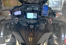
Garmin Zumo 665 with XM Radio. Works great when you out of cell service, which I found often when riding to Sturgis. I found a lot of places like Beartooth pass, Chief Joseph Highway, and many other places in Montana and Wyoming. I program my own routes with gas stops and lodging into my Garmin.

IMG_4162A.jpeg
 
Back
Top